Thursday, April 20, 2023

Walk 10. Chatham to Rainham

 Today begins back at Chatham Bus Station. Just around the corner is the bank of the Medway and a nice landscaped riverside walk…


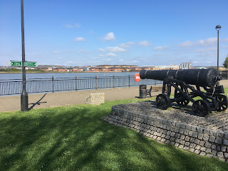
I pass these old guns (still guarding the river) on my way past the Medway Council offices…


Beyond the offices lies the Chatham Historic Dockyard. As a paying visitor attraction, you can’t just wander through! This requires a detour onto a very busy duel carriageway to get to the other end. And it’s bloody massive! About twenty minutes later I’m at the other end.

The dockyard was once one of the Royal Navy’s main bases. At its height, it was much bigger than what remains today and included St Mary’s Island. There are several historic ships that can be explored including a submarine (as long as you can fit through the hole!). It is also home to the famous ‘ropery’ that makes, well, ropes. When it was built the ropery was the longest building in Europe, or maybe the world? Either way, it’s very very long!


What a load of anchors…


From the dockyard it’s on to St Mary’s Island. The western two thirds have been completely re-developed over the last few years and are home to loads of trendy flats and houses and a marina. There is a nice riverside walk all around this area. The eastern end of the island is an industrial estate with no public access. There is a helpful sign with a map…


If you are into gin this looks like the place to go…


Along the first part of the path is a good view of Upnor Castle on the other bank, which was completely hidden when I actually walked past it!


St Mary’s Island is bigger than I was expecting and takes about forty-five minutes to circumnavigate and get back to the mainland. Still, the views were good!


Next is another busy road section that continues for over half a mile until I reach an Asda and the England Coastal Path re-appears after a jaunt inland! Round the back of Asda is Gillingham Piers where I find this beauty…


The Medway Queen is a paddle steamer that started life in 1923 as a ferry from Strood to Southend and Herne Bay. During the Second World War she took part in the evacuation from Dunkirk then served as a minesweeper. After being retired from ferry use in 1963 she was moored on the River Medina on the Isle Of Wight and was used as a nightclub!

From here I walk round a block of buildings to the Strand Leisure Park. This has kids play areas, a water sports centre, tennis courts, a miniature railway, and ice creams! Here I spot what looks like the Sheppey Crossing in the distance…


There is one last industrial unit to skirt and the rest of today’s walk will be all beside the water with greenery to the landward! Most of the next hour looks like this…


Soon I come to the strangely named Horrid Hill. Basically a blob of land in the estuary mud connected by a causeway, it seems very popular with dog walkers and others just out enjoying the spring sunshine. There is a nearby car park at the Riverside Country Park so access is easy! According to the information board the origin of the name is uncertain…


About five minutes later I find the remains of another boat. I wonder how long this one has been decomposing in the mud…?


Shortly I reach Bloors Wharf, another old and disused industrial site, which is pretty much the end of today’s walk. This also has a helpful information board…


So that’s it for today. I’m pleased to have completed the very urban Medway Towns area and will be back out in a more rural environment for a while. Next time I will be starting at Motney Hill, a small peninsula with a sewage works on it. Can’t wait…

Tuesday, April 4, 2023

Walk 9. Hoo St Werburgh to Chatham

 I start today at Hoo Marina which is a right old jumble of boatyards and other light industrial workshops. The path threads its way through several alleyways, although fortunately it is well signposted otherwise it would be easy to get lost!


Once that lot is navigated, the path goes through a yacht club with a load of boats of various sizes.


Past the yacht club the path continues along the shoreline. This becomes impassable at high tide so check the tide tables before setting off. The shore is very muddy and helpfully it started to rain as soon as I set foot on it! 


Within a few yards I come across Cockham Wood Fort. Built in the 1660s in red brick, it is now being eroded by the sea and large chunks have broken off and lie in the mud. I would have liked to stop for a better look but it was starting to rain harder so I kept going!


A bit further on is today’s derelict pillbox. Every walk has to have at least one!


The muddy beach comes to an end as I approach Lower Upnor. A firm path starts and the rain stops!


Taking pride of place on the seafront at Lower Upnor is this lady…


Although the building behind the figurehead is closed and up for sale, the Shaftesbury Young People Trust is still an active organisation helping to improve the lives of young people.

Between Lower and Upper Upnor lies Upnor Castle. Owned by English Heritage it is open to the public from April to October. It sits in sizeable grounds which block access to the shore entailing a short detour inland, much of it following the old wall of the estate.


The path emerges at the top of the incredibly picturesque Upnor High Street…


At the bottom of the High Street the path leads to another stretch of muddy shoreline. Even muddier than the last, it fortunately is only a few yards long!


From here the path turns inland again to bypass a large industrial estate that has no public access to the riverside. Over a hill and skirting Frindsbury, I get back to the river near Stroud railway station. Unexpectedly there is a submarine here! Even more unexpectedly it turns out to be an old Soviet submarine from the 1960s! Once used as a visitor attraction, it is now closed and awaiting restoration.


This area looks very sad. In the fairly recent past it has obviously had some money spent on it, nice railings, benches, kids playground etc, but now it seems uncared for, full of litter, graffiti, supermarket trollies, dog crap and so on. But there are no people. Not even a dog walker! What a waste…


Round the corner is Rochester Bridge which crosses the Medway with a view of Rochester Castle and Rochester Cathedral. Both well worth visiting, the Castle was besieged during the Barons’ revolt against King John and the Bishopric of Rochester was the first to be founded by St Augustine after he converted the pagan Kingdom of Kent at the end of the Sixth Century. There is also an interesting little high street close by.


The final part of today’s walk is a bit of a trek through Rochester and Chatham to its finish point at Chatham Bus Station. A lot of this area is being redeveloped with seemingly endless riverside apartment blocks. The Medway towns area is obviously receiving a lot of investment as the next walk will take me through more new housing that has been built on the site of the old Chatham dockyard. Even the bus station looked fairly new! I wonder if this is a result of the Medway Unitary Authority being formed twenty-odd years ago and given administrative independence from Kent? 

Anyway, that’s it for today! Next time I finish the rest of ‘Medway City’ and head back out to estuary marshland and rejoin the Saxon Shore Way!