Tuesday, March 12, 2024

Walk 24. Broadstairs to Sandwich

 What’s this? Sunshine? Blue skies?

It’s actually NOT raining today! So I’m taking advantage of the weather and doing the next leg of the Kent Coast.

The start today is Broadstairs, although the bay is called Viking Bay.


From up here there is a much better view of Dicken’s Bleak House than I was able to get last time…


I head south along the sea wall through the tiny Louisa Bay, along South Cliff, and past the interestingly-named Dumpton Point.


In Dumpton Bay the sea wall ends and I continue along the sand. This is another section that cannot be accessed at high tide as the water reaches the cliff face. 


It looks like those warning signs are needed as a couple of minutes later I pass a rockfall that looks quite recent!


Approaching Ramsgate the sea wall reappears, and I walk along it into the town passing the entrance to Ramsgate Tunnels. Today this is a visitor attraction, but originally these tunnels were used during WW2 as air raid shelters for the civilian population.


Shortly after, I reach Ramsgate harbour. This is still a working harbour with a lot of industrial-looking areas together with interesting old buildings and touristy-type businesses. Quite a mix! Here is a selection of sights…


The road continues along the bottom of the cliff towards the Pegwell Tunnel where it heads inland.


The pedestrian path continues to the left for a short distance then the sea wall ends and there is a nicely landscaped way up to the cliff top at Pegwell.


From the top, there is a great view out over Pegwell Bay…


The road through Pegwell has a nice selection of picturesque buildings…


…and then the path turns left down a lane, past a few houses, and then becomes a bit overgrown as it follows the cliff top down into the bay.


The path gently descends into Pegwell Bay and flattens out at this large expanse of disused concrete that is slowly being reclaimed by nature…


This is the remains of the hoverport used by the cross-channel hovercraft. Increasing costs forced the service to close in the early 1980s, but in their heyday these giant beasts carried millions of passengers and their cars across the channel in a fraction of the time that it took a traditional ferry. Today, if you want to travel by hovercraft, you will have to head for Portsmouth where the ONLY regular passenger-carrying hovercraft service in the WORLD will take you to the Isle of Wight.

Hovercraft are cool.

Hidden in the bushes at the back of the concrete apron is a set of steps that takes me up to the road through Cliffs End. Here I find a magnificent replica of a Viking ship! This is pretty cool too…


About five minutes up the road from the Viking ship is Pegwell Bay Country Park. This is a marshland wildlife habitat with some well-maintained paths, and seems to be popular with dog walkers!


The park doesn’t  take long to walk through, which is unfortunate because the rest of the walk to Sandwich is along a very straight, very boring road that looks like this…


After fifty minutes I finally arrive in Sandwich at the small bridge over the River Stour. After the monotony of the road section, Sandwich offers some interesting stuff to end the walk with. A strange little bridge…


Some boats, including a Cold War era US Navy patrol boat…


And what looks like it might have once been a medieval gatehouse to the town…
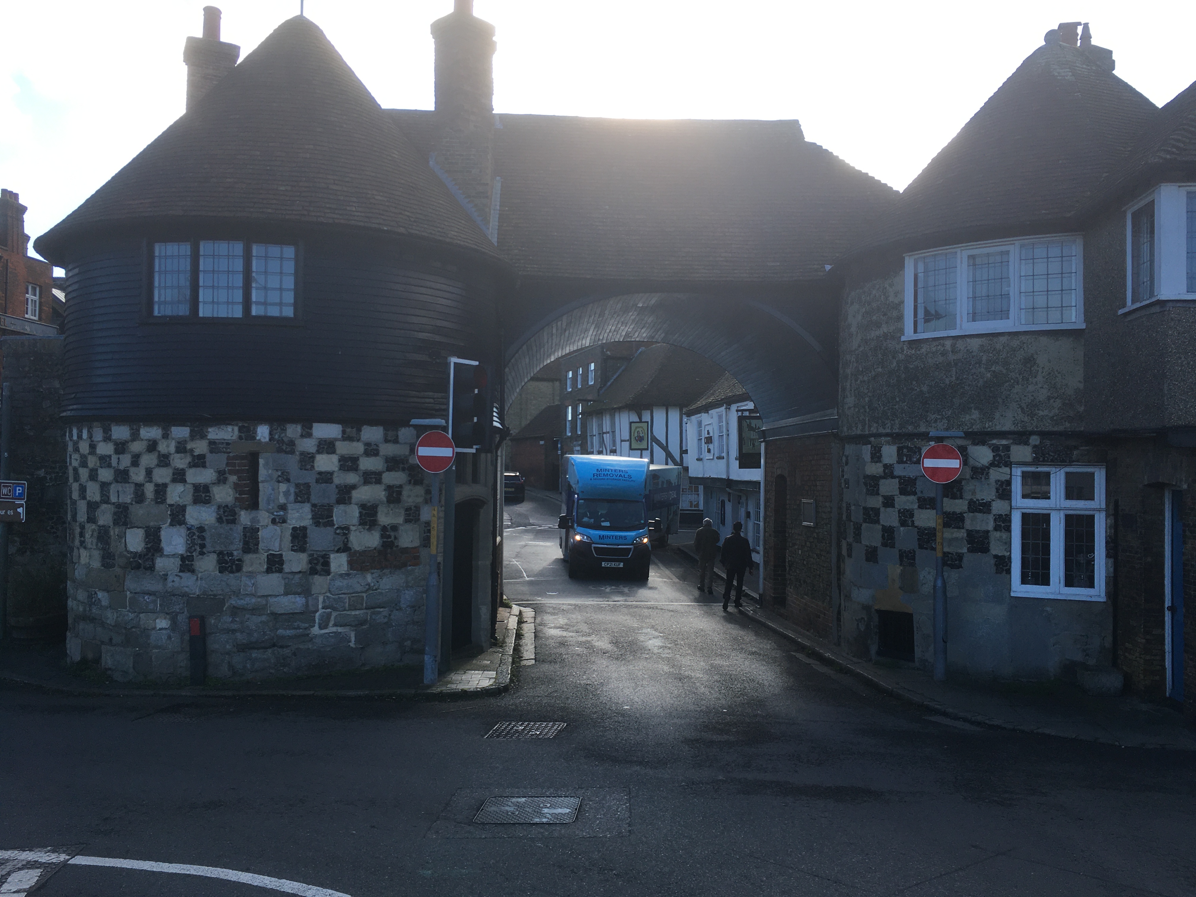


So that wraps it up for today’s walk, which can be summed up, I think, by the word ‘variety’!


Wednesday, January 31, 2024

Walk 23. Birchington to Broadstairs

 So, after a short break for unpleasant weather and Christmas, here is the next exciting instalment of the Kent Coast Walk!

Starting back at Birchington I head along the sea wall at the base of the low chalk cliff…


After a couple of minutes I pass a derelict building half way up the cliff. I wonder what it was used for as it doesn’t look like an old pillbox or other military installation, but it’s a weird place to have a house.


Soon I round a headland into the very small Epple Bay. As I quickly discover, traversing small bays will be a big feature of today’s walk!


On the far side of the bay, where the chalk begins again, there is no way round the base of the cliff. Maybe it’s accessible at low tide, but for now I climb the stairs and continue along the cliff top road into Westgate Bay.


Westgate Bay has a prom to walk along, beach huts and a nice-looking cafe…


…but is soon left behind as I round another small headland into St Mildred’s Bay. This offers much the same amenities as the previous bay and again, doesn’t take long to walk through.


Round the next headland and I’m now approaching the famous old seaside resort of Margate.

I approach the town along the prom at Westbrook Bay, which forms the western half of Margate bay. The other half is just called The Bay!


Coming into Margate itself I pass some houses with a real ‘sea view’…


…some funky-looking cafes, one of which is in a double decker bus…


…and a Herne Bay rivalling(?) clock tower…


Just across the road is the iconic Dreamland. Once the home of theme park rides, a ballroom, cinema, and various other attractions, Dreamland has closed and been rescued several times over the last couple of decades and is now a shadow of its former self…


Margate is a bit strange, a mixture of utter dereliction and decay interspersed with new investment. It seems to have ambitions of being the Brighton of Kent, but with a more arty flavour!

Talking of art, as I pass the jetty…


…I come to a significant investment in art…


The Turner Contemporary is free to enter and apparently has quite an impressive collection. I didn’t go in myself, partly because I didn’t really have time, but mostly because I’m an uncultured lout…

Anyway. Moving on. A few minutes later I pass some decay! A large concrete structure covered in graffiti which may have once been a beach-side lido.


From here I continue along the sea wall through Walpole Bay…


About fifteen minutes brings me to Palm Bay. Here I run out of wall and have to continue along the sand, which is nice and all but does require more effort!


At the far end of Palm Bay lies Foreness Point. The shoreline here is blocked by some sort of water company installation so I head up the path to the cliff top.


Up on top, I walk along the low cliff to Botany Bay (no, not that one…) where there is a cool chalk stack!


Continuing along the cliff top to the headland between Botany Bay and Kingsgate Bay I find an 18th Century folly built in the style of a Henry VIII fort…


Heading into Kingsgate Bay there is a great view of Kingsgate Castle on the far side of the bay. Another 18th Century building, this is now divided into, presumably expensive, flats.


Through Kingsgate the path follows a short detour away from the coastline, and follows the road down into Joss Bay where it heads back onto the cliffs along the side of a cabbage field. This is the most easterly point in Kent and is marked by a lighthouse up the hill…


The path continues in front of some pricey-looking houses…


…before being blocked by private land again. I take another, slightly longer, diversion inland along the road towards Broadstairs. On the outskirts of the town the coast path dives down an alley and emerges onto the beach at Stone Bay.


I’m now just a short walk from Broadstairs pier/jetty where I’m finishing today’s walk. I pass Bleak House where Charles Dickens came to write in the 1840s and 1850s, and is today a Dickens museum I believe. Its hard to tell from down below but I think it is this building…


So here I am at the end of today’s bay-tastic walk. I’ll leave you with a couple of photos of the pier area…